On Saturday December 30th, we completed our annual Christmas Bird Count.
The Numbers:
- 23 + 7 participants; 715 km driven; 10.5 km walked; 2.5 hrs owling; -14ºC minimum;
- 38 species overall; estimated 3983 individual birds overall;
- most populous: American Crow 931, Snow Bunting 740, European Starling 342, Dark-eyed Junco 335, American Goldfinch 300, Black-Capped Chickadee 272, Wild Turkey 223,
- least seen: Ruffed Grouse 1, Northern Harrier 1, Sharp-shinned Hawk 1, Cooper’s Hawk 1, Snowy Owl 1, Belted Kingfisher 1, Northern Shrike 1,
- Christmas Bird Count participants: (23 participants):
(Area 1): Ron Jasiuk, Bill, Mike, Russ, Cynthia, Leo;
(Area 2): Mark Whitcombe, Jerry, Paul, Katherine;
(Area 3): Linda Lockyer, Mike, Dilys, Debby;
(Area 4): Ron Ritchie, Mary Lynn, Betty;
(Area 5): Dawn Renfrew, Darcie;
(Area 6): Rob Best, Kevin, Anne-Marie, Suzanne
- Christmas Feeder Watch participants: (7 participants):
Doug & Jane, Jean, Joan, Robin, Rachel, Liz
Northern Shrike (by Kevin Tipson)
Comments (by a botanist …)
Of note, the cold weather we’ve been having through much of December meant there was very little open unfrozen water, so the geese and other waterfowl including gulls that cluster around water were mostly absent. Northern visitors (i.e., Dark-eyed Juncos, Snow Buntings and Pine Siskins) were present, but few of the more sporadic irruptives were seen. The most notable of these were the one Northen Shrike, and the one Snowy Owl reported by a non-member south of Orangeville along Highway 10. Crossbills, etc., were not reported. (I suspect the excellent seed and cone production during last summer’s well-watered growing season have kept those birds farther north.)
Approximately three-quarters of the total number of individual birds came from 7 out of the 38 species, mostly from those species that congregate in large flocks in winter often taking advantage of agricultural leftovers, i.e., American Crows, European Starlings, Wild Turkeys. On the other end, 7 species were represented by only 1 individual bird.
In Area 2, south-east from Caledon, we certainly noticed that over a third of birdfeeders maintained and filled in previous years were inactive. That certainly reduced the number and the diversity of species we saw both in residential areas, and along the rural roads near houses.

Dark-eyed Junco (by Paul Blayney)
Comments from Russ (a birder!)
- Up Trend: Highest number of Red-bellied Woodpeckers (20) versus 12 last year which was then the highest count. Red-bellied Woodpeckers were first seen in 2006 (1 bird) and then not seen again until 2010 (2 birds).
- Down Trend: House Sparrows at 16. Average the last five years is 30. Average for the first five counts (1987-91) was 441.
- Not a trend, but, rather surprisingly, we saw record numbers of Juncos, Snow Buntings and Grackles (2).
- On the Snow Buntings, a large flock was seen in both Areas 4 and 6, which adjoin on Hwy 9. I wonder if it was the same flock (estimated at 340 and 400 birds).

Snow Buntings (by Kevin Tipson)
The Pattern
All of this fits with the pattern reported to Ontario Birds by Josh Vandermuelen, one of the aggregators on that site:
“The unrelenting cold weather that has descended upon even the most southerly reaches of the province has limited the number of lingering bird species being discovered, and as a result the Ontario winter bird list is lower than it has been by this date in previous winters.
“Since my last update on December 14, eight new species have been added to the list, bringing it up to 192. In comparison, last year by this date the winter bird list was 207 species, finishing at 216 species. The new additions since my last update are: Vesper Sparrow (Ottawa, London, Sandbanks), Brewer’s Blackbird (Long Point), Tufted Duck (Mississauga to Toronto), Eastern Meadowlark (multiple locations), Indigo Bunting (Seeley’s Bay), Lincoln’s Sparrow (Toronto), Ovenbird (Toronto) and Rose-breasted Grosbeak (Brantford).
“There are very few remaining expected species. Some of the more likely species to be added to the list over the next two months include Boreal Owl, Fish Crow and Pine Warbler. Other species missing from this winter’s list that are more unusual but still observed most winters include Eared Grebe, Black-headed Gull, California Gull, Slaty-backed Gull, Harris’s Sparrow, Spotted Towhee and Gray-crowned Rosy-Finch.”
(ONTBIRDS is presented by the Ontario Field Ornithologists (OFO) – the provincial birding organization. For information visit
ONTBIRDS )
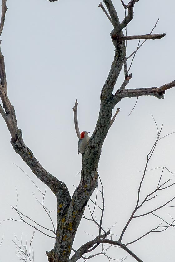
Red-bellied Woodpecker (by Kevin Tipson)
Overall
All in all, an excellent experience again this year! Important data was gathered and submitted to the Audubon Society. Citizen Science is important! We had good times together. We welcomed new and accomplished members, and welcomed back some great friends whom we’ve not seen much of. I’m sorry to have missed the wonderful potluck and post-count gathering hosted by Kevin and Carol.
Thanks to Ron Jasiuk and Russ Macgillivray for organizing this important UCFNC annual event! (If you wish more complete information, please Contact us!